Climate resilience depends on knowing what is happening on the ground — and knowing fast. We track wildfires that can release hundreds of millions of tons of CO₂e annually, we assess weather damage to utilities and infrastructure, and we enable solar siting and precision agriculture. Yet, the tools we rely on are flawed.
Satellites, while global in reach, are often too coarse (30 cm+ resolution), too costly, and too infrequent in coverage to provide the immediacy required. Fixed-wing aerial imaging provides higher resolution but at high expense, limited coverage, and logistical hurdles, and it requires pilots, permits, and planning. As a result, the most critical imagery is often unavailable in the moments when it matters most.
Near Space Labs offers a solution: a way to scale ultra-high-resolution, real-time Earth imaging with a fraction of the friction.
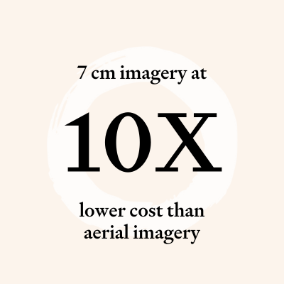
Near Space Labs has developed autonomous stratospheric gliders, called Swifts, that deliver ultra-high-resolution Earth imagery (7 cm/pixel and better) at significantly lower cost, faster turnaround, and broader coverage than traditional aerial or ground-based imaging solutions, while outperforming commercial satellites (30 cm/pixel) on both quality and revisit rate.
Operating in the atmospheric layer between 20–100 km, Swifts avoid adverse weather and congested airspace while maintaining proximity to Earth for detailed imaging. Each balloon-borne robot traverses hundreds of miles in a single flight, covering regions as large as Dallas–Houston or New York City in a couple of hours.
With 125 Swift units, Near Space Labs provides global coverage in the continental U.S.. In addition, unlike satellites locked in orbit or manned aircraft constrained by cost and logistics, Swifts can be rapidly deployed anywhere, any time, with no permits required.
.png)
The benefits of earth observation using stratospheric balloons is not novel. At GoogleX, Tom Chi (At One Ventures’ Managing Partner) was on the founding team of Project Loon, which deployed internet-beaming balloons in the stratosphere to bring internet access to rural, remote areas. Project Loon achieved remarkable milestones, such as launching the world’s first balloon-based internet service in Kenya, but didn’t scale commercially prior to shutting down. Near Space Labs solved key technical challenges in landing and retrieval through design choices and proprietary control systems, achieving what no other balloon program has been able to do.
Near Space Labs delivers satellite-beating resolution at 1000X lower CapEx and launch costs. Compared to aerial imaging providers, their cost structure is ~10X lower, without the delays of planning, permits, or pilots.
.png)
The environmental impact of Near Space Labs is unfolding, but already points to wide-ranging applications. Its data is expected to improve wildfire response (where U.S. events release 100-400M tons of CO₂e each year) by enabling earlier detection and faster intervention. Its imagery also strengthens grid resilience by tracking vegetation growth, identifying post-storm damage, and supporting urban infrastructure monitoring as extreme weather intensifies.
Near Space’s ability to continuously monitor the Earth also allows for better understanding and prediction of risk. This enables insurance companies to underwrite in areas where they otherwise weren’t able to before. As climate change continues to put more stress on our built environment, insurance that actually works for people becomes the tool for building financial resilience in the face of climate change. Near Space’s data not only strengthens the underwriting and risk modeling side but also helps with rapid post-catastrophe payouts. It is proven that households with insured properties are 37 percent more likely to have been rebuilt than uninsured properties. This is crucial in building a resilient future for our planet.
Additional opportunities include delivering lower cost, up-to-date imagery for precision agriculture and solar sales and design. These applications can boost crop yields, help with food security and accelerate renewable adoption.
At the center of this story is NSL’s ability to innovate quickly. Satellites demand long development cycles, carry launch risks, and face regulatory hurdles. NSL avoids these barriers, enabling rapid integration of new sensors, flexible deployment, and expansion of coverage at a fraction of the cost. This is a virtuous cycle that rolls out environmentally helpful innovation quicker.
This includes methane detection, where Near Space can offer three to five times faster than satellites, detecting 1.2 gigatons more in emissions in the next 20 years than satellites.
Near Space Labs is currently scaling in property insurance, where imagery is critical for underwriting and claims after disasters. Today, the industry depends on costly, inflexible aerial imaging that often is unavailable, and post disasters can be delayed for days or weeks. USAA, a leading U.S. insurance provider, has invested in this Series B.
Currently, the company is expanding its nationwide Swift robot network serving Fortune 500 insurers and other mission-critical organizations across multiple industries.
Near Space Labs was founded by Rema Matevosyan (CEO), Dr. Ignasi Lluch (CTO), and Dr. Albert Caubet (Chief Engineer) - engineers and physicists with deep experience in aerospace and space research. The team met at the Skolkovo Institute of Science and Technology before joining the Urban-X accelerator in New York.
.png)
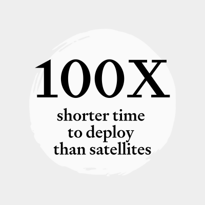
"Near Space Labs has achieved what many in the stratospheric technology field have long pursued – making high-altitude robotics operationally and economically viable at scale. The ability to deploy purpose defined imaging over huge areas with short deployment lag and at dramatically better cost structure than aircraft or drones can redefine entire industries. With better resolution and 100X shorter time to deploy than satellites, and a cost structure and operational complexity that is 10X cheaper and easier than getting similar images by plane or drone. This capability will allow numerous industries to get images they need, in exactly the bands that provide the best insights, and over exactly the assets they specifically care for, with a quick turnaround.”
— Tom Chi, Managing Partner, At One Ventures